National Mapping’s Track Making Scraper for Sandy Going
Compiled by Paul Wise, 2014-2019
Introduction
The joint 1947 agreement between the United Kingdom and Australia saw the start of the development and testing of guided weapons systems in Australia. The testing would take place on the rocket range that stretched from Woomera in South Australia north-west to Talgarno on the Western Australia coast some 170 kilometres south of Broome. This joint defence project, was to be managed by the Weapons Research Establishment (WRE), now the Defence Science and Technology Organisation. The Woomera Rocket Range was selected by the European Launcher Development Organization (ELDO) as the launch site for its first space vehicle Blue Streak project. Since much of the value of the Blue Streak lay in how closely to the target it could land its nuclear warhead at the end of its long ballistic trajectory, the Talgarno area was to be well instrumented to fix the point of impact to within 30 metres. WRE therefore required National Mapping’s geodetic survey control in the Talgarno area by the end of 1959 so as to be ready for the first test launch of the Blue Streak’s first stage rocket, planned for 1960.
The Australian Geodetic Survey
At that time the geodetic survey of Australia had been completed from the south-east, north to Aileron (about 130 kilometres north of Alice Springs) then generally north-westerly through the old Granites and the deserted Tanami goldfields to Halls Creek and Derby. To meet WRE’s requirement, during 1958 and 1959, a 4 400 kilometre loop between, Alice Springs - Finke - Giles - Rawlinson Range - Roy Hill - Derby - Halls Creek - Alice Springs, was surveyed. Nat Map completed this work in late 1959 only to learn that the British Government had announced the Blue Streak project's cancellation.
Assisting Nat Map to meet the 1959 deadline, WRE supplied men and materiel along with the services of its track making capability led by WRE range reconnaissance officer Len Beadell. The track made by Beadell’s team connecting Giles Meteorological Station to Carnegie Homestead via Warburton enabled the Nat Map survey team to progress the geodetic survey west to Carnegie Homestead, then north-west to the Carnarvon Ranges, Ophthalmia Range, and to Roy Hill where it joined the Western Australian Survey Department work. Beadell’s tracks while being of great assistance to Nat Map accessing the region were also for future rocket recovery purposes. After the test firing and rocket impact, the parts were to be collected for return to Woomera for examination by the scientists via these tracks.
Remnants of a test rocket on Nat Map vehicle’s roof after finding and collecting at the request of WRE in 1965 (courtesy Kevin Snell).
Now with the 4 400 kilometre loop for WRE completed, there still remained the huge area of the Great Sandy Desert awaiting survey. From near Sandy Blight Junction in the Northern Territory the geodetic survey would first be taken west to Well 35 of the Canning Stock Route. Then from Well 35 further west to just north of Callawa, Western Australia to again join the existing Western Australian Survey Department work. Next would be a north-south survey from around Halls Creek to Young Range, between Warburton and Carnegie Homestead via Well 35.
The survey work west from Sandy Blight Junction was to commence in 1961 so in preparation Beadell’s track making team had started the track, as determined by Nat Map, that would take its survey team close to the required survey points. At some 160 kilometres past Pollock Hills in 1960 Beadell’s grader suffered catastrophic gearbox failure. Setting out to (successfully) tow the grader to Giles with the bulldozer, near Mount Webb, their Commer ration truck caught fire and was burnt out.
Thus in 1961 when the geodetic survey team reached the literal end of the track to Well 35, the remainder of the survey would be along a track of their own making. While Nat Map’s Bob Bobroff, along with Bob Goldsworthy and Bill Johnson completed the 200 kilometre reconnaissance to Well 35, thus being the first to take vehicles to this part of the Canning Stock Route, the remainder of the party, dug Jupiter Well. This well saved the further carting of water from Liebig Bore, some 600 kilometres to the east. In May 1963, Nat Map’s wheel tracks into Well 35 were replaced with a WRE graded track.
The original plan for the geodetic survey to now be progressed from Well 35 west to Callawa in 1962 now had to be rethought as WRE’s track making services would be unavailable. Taking a fully equipped survey party into Well 35 over 200 kilometres of just wheel tracks and to then continue for another 400 kilometres of survey over unknown and pristine spinifex and sand entailed too many risks.
National Mapping’s Track Making Scraper for Sandy Going
The decision was thus taken to reverse the route and access Well 35 from Callawa. To remove some of the strain on the majority of the vehicles, a track scraper consisting of a rectangular angle iron frame with a V shaped prow of heavy red-gum plank, was to be towed by the lead vehicle. Thus was made, the National Mapping Track Making Scraper for Sandy Going.
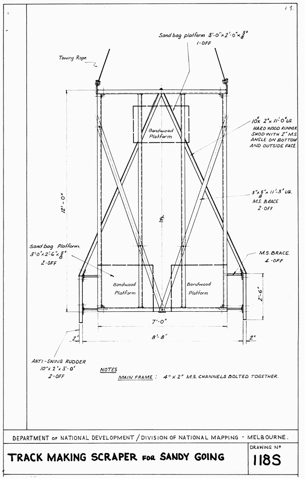
Plan drawn for National Mapping’s Track Making Scraper for Sandy Going.
The scraper was described as having a top framework of 4" x 2" channel iron, constructed for unbolting for transport. The cutting blades were of 10" x 2" hardwood, shod along the bottom and outside bottom with 2" angle iron; 10" x 2" x 30" wooden rudders prevented the scraper swinging in rough spinifex. The prow was iron shod. Bondwood platforms carried sandbags, and it was important to adjust the weight of those bags according to the roughness of the spinifex. The weight of the scraper had to be just sufficient to smash and smooth sand and ant encrusted spinifex without digging a deep channel or making heavy pulling. Please also refer to the plan of the Nat Map scraper above.
National Mapping’s Track Making Scraper at work in 1962 near Citadel Hill on the Callawa – Well 35 survey route.
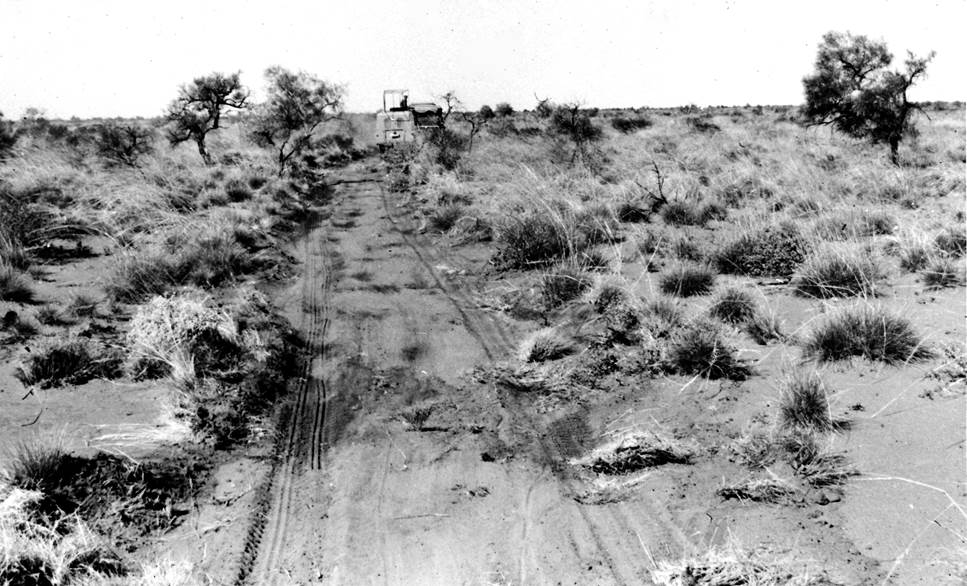
The track left by National Mapping’s Track Making Scraper in 1962 in the Great Sandy Desert.
In some ways the scraper’s performance could be described as being more trouble than its worth. While it did what it was asked its maintenance and the toll it took on the towing vehicles saw its use terminated some 210 kilometres from Callawa with still the same distance to go. After that the route to Well 35 was just wheel tracks, but being very well defined by the end of the survey. These wheel tracks formed the route for WRE to later grade a more substantial track in 1963 after completing the unfinished section from Jupiter Well.
The survey party having reached Well 35 returned to Callawa along the route they had just made and back to Melbourne. Bill Johnson however, headed north to complete the reconnaissance for the future Halls Creek – Well 35 section of the geodetic survey. Johnson arrived at Billiluna Homestead in October 1962 with just a little petrol left and almost no food. From Well 35 Johnson drove alone northwards generally on or close to the Canning Stock Route. Being the first vehicle in this area the stock route was only indicated by Canning’s wells. The route he chose was primarily for the later Nat Map geodetic observing party to follow to access the highest points of the terrain that would give line of sight along the geodetic traverse route. To avoid the observing party having to cart water over great distances, Johnson also inspected and reported on the condition of wells on the Canning Stock Route (CSR) that were conveniently located in relation to the proposed traverse route. However, by Well 51 the higher terrain features needed to carry the survey traverse were away generally to the north-west. Johnson therefore took his reconnaissance route in that direction enabling the proposed traverse to make the necessary connection to the existing survey around Halls Creek.
Johnson was aware that significant time and vehicle wear and tear could be saved if the survey points on the geodetic traverse south of Minnie Range could be accessed via Well 51 from the graded road that then existed between Billiluna and the Balgo Mission. However, a suitable track across approximately 30 miles (48 kilometres) of country between the Billiluna-Balgo road and Well 51 did not then exist. Johnson’s own travel route northwards from Well 51 precluded his reconnaissance for such a new connecting track. Nevertheless, Johnson arranged a contract for Mr Bill Moyle of Carranya Station to undertake the scraping of the new track to Well 51 and to then continue with further track work southwards to Well 45. For this work Moyle used his own equipment as the Nat Map scraper had returned to Melbourne with the survey party in 1962. Moyle completed the 160 miles (250 kilometres) of track scraping in early 1964, just prior to the survey work being commenced by Nat Map. While this route was generally clear of sandridges the terrain was very rough and a track to the start of the formidable sandridges would reduce the strain of the fully equipped survey vehicles. The unofficially named Moyle’s Track ran from the vicinity of Old Billiluna [Homestead] to Well 45, bypassing Wells 47 and 46 to the east.
Supervising Surveyor Johnson wanted the 1964 survey party to scrape the remainder of the track over the sandridges from Well 45 to Well 35 a distance of some 200 miles (300 kilometres). The lessons learned in 1962 from towing the Nat Map track making scraper were not forgotten, especially by those closely involved at the time. The then Bureau of Mineral Resources offered the use of two Bombardiers, a very light weight tracked vehicle designed for pulling snow ploughs; to go with these was a tracked trailer. BMR assured National Mapping that these vehicles were good performers in the sand. The plan was then for one Bombardier to pull the track scraper used in 1962 which had been modified to improve its performance. The other Bombardier would tow the tracked trailer loaded with petrol and the survey beaconing sections.
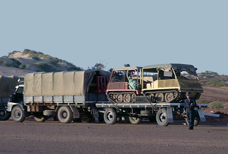
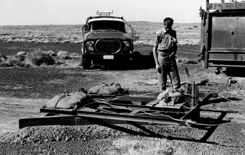
Broome 1964, the two Bombardiers on their trailer with the tracked trailer just visible out of the rear of the Bedford tray,
on the way to Well 45 (courtesy Kevin Snell).
The geodetic survey was progressed quickly from near Halls Creek south to Well 45. As the survey party moved into the desert the Bedford trucks and trailer now returned to Halls Creek. They remained there and kept daily contact by radio in case of emergency. When the survey party was approximately halfway to Well 35 the trucks and trailer left Halls Creek for the 1 400 mile (2 250 kilometre) trip to Well 35 via Derby, Broome and Port Hedland, collecting a load of petrol and required supplies from the last named town. At Well 35 they would meet the survey party coming down from the north.
The survey party was now ready to extend the geodetic survey south to Well 35 relying on the Bombardiers and track making scraper to perform their tasks; but they failed!
The tracked trailer was much too heavy to be towed over the high sandridges in this area with any load; the scraper could be towed along the flat but not over the sandridges unless both Bombardiers were used in tandem. As the survey party had to try and scrape the track the only solution was to not take the trailer. Unlike the other survey excursions into the desert water was not a problem as Johnson had reported on many of the wells he passed during his reconnaissance so its presence and quality was known.
Towing the scraper, the two Bombardiers in tandem just managed to get it over the ridges; watching them do this reminded one of a dog on a slippery floor - all movement and no traction. The track made by the scraper on the flat was fairly good but the Bombardiers loosened up the sand too much on the ridges, particularly for the first vehicle following. Eventually the constant strain on the motor was too much for the six cylinder Chrysler side valve Bombardier engine. All track scraping operations ceased about 8 kilometres south of Well 41; about ninety miles of track being completed and about 110 miles still to go to reach Well 35. The survey party now made the sandridge crossings by hand and the wheel tracks of the 5 survey vehicles soon formed a reasonable track. The survey was successfully completed to Well 35.
Following the 1964 survey and Moyle’s work a scraped track had been left between Wells 41 and 51 and very well defined wheel tracks between Wells 35 and 41. Despite this track bypassing Wells 46 and 47 to the east, the scraped track was and still is defined on many maps as the Canning Stock Route. This track could still be clearly seen when Wenholz et al arrived in 1967/68. Up until a track was found/made that permitted travel between Well 45 and Well 48 via Wells 46 and 47, many vehicles traversed this route as being the only access approximating Canning’s Stock Route.
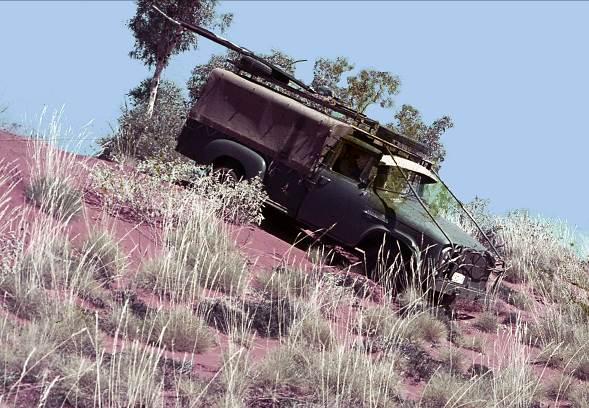
The resting place of National Mapping’s Track Making Scraper for Sandy Going
When track scraping operations by Nat Map were abandoned in 1964 some 8 kilometres south of Well 41 what became of the track making scraper was never documented. It was said by the Natmappers involved in the 1964 survey that the track scraper never came out of the bush, so was presumably towed safely clear of the track and left. It was not until Russell Wenholz et al in 1967/68 came across the scraper on the eastern side of the track that its whereabouts was confirmed. In recent communications Russell stated…My personal diary notes that in 1967 two blokes in our team hooked it onto the back of a Rover and dragged it "a mile or so" south. I recall it as being close to the track.
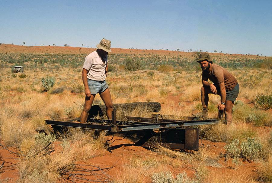
National Mapping’s Track Making Scraper for Sandy Going, photographed by Dave Morton in 1980,
with (L-R) Peter Lean and Bob Anderson, supplied by Phil Bianchi.
Dave Morton’s 1980 photograph of the scraper, which has only just emerged thanks to Phil Bianchi, is as far as anyone knows, the last time the scraper was imaged. In this image the scraper does not stand any higher than the surrounding vegetation and another 40 years on (from 1980) it is slowly rusting away to the same colour as the sand. If the Rover in the background in on the track then the scraper is well away from passing vehicles making chance discovery today even more difficult. If the country is vegetated as it was in 2010 as shown in the image below by Laurie McLean, without a concerted effort it is suspected that the scraper may continue to rust in peace.
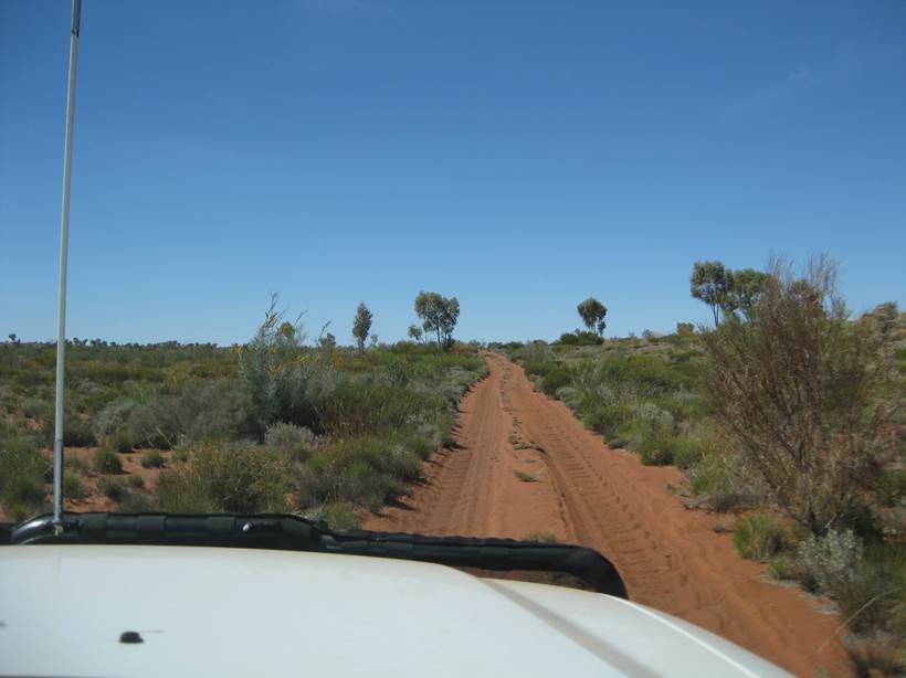
The country between Wells 40 and 41 in 2010 (courtesy Laurie McLean).
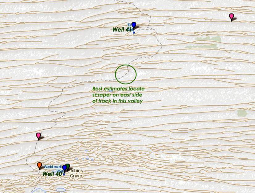
Best estimate of Nat Map’s scraper’s location between Wells 40 and 41 (map section courtesy Peter Gargano).
Closing remarks
About forty years ago, some 8 kilometres south of Well 41, the Nat Map track scraper was last confirmed to exist around where it was abandoned by the 1964 survey party. Its design being for use in sandy country, without undergoing significant modification its use for other purposes on harder surfaces is highly unlikely. Given knowledge of the scraper and its location was largely unknown until say the 1980s or even later, added to its isolated and questionable location, indications are that it still lies where it was left.
We may never know……and that may be a good thing!
Acknowledgements
The efforts of Russell Wenholz in accessing his diaries and associated information on his finding the scraper in the late 1960s is acknowledged, as is Phil Bianchi for the 1980 photograph taken by Dave Morton and Natmapper Laurie Mclean for his 2010 photograph. The website by Peter Gargano is acknowledged as the source of the map section.